Homesteads in the Matanuska Valley
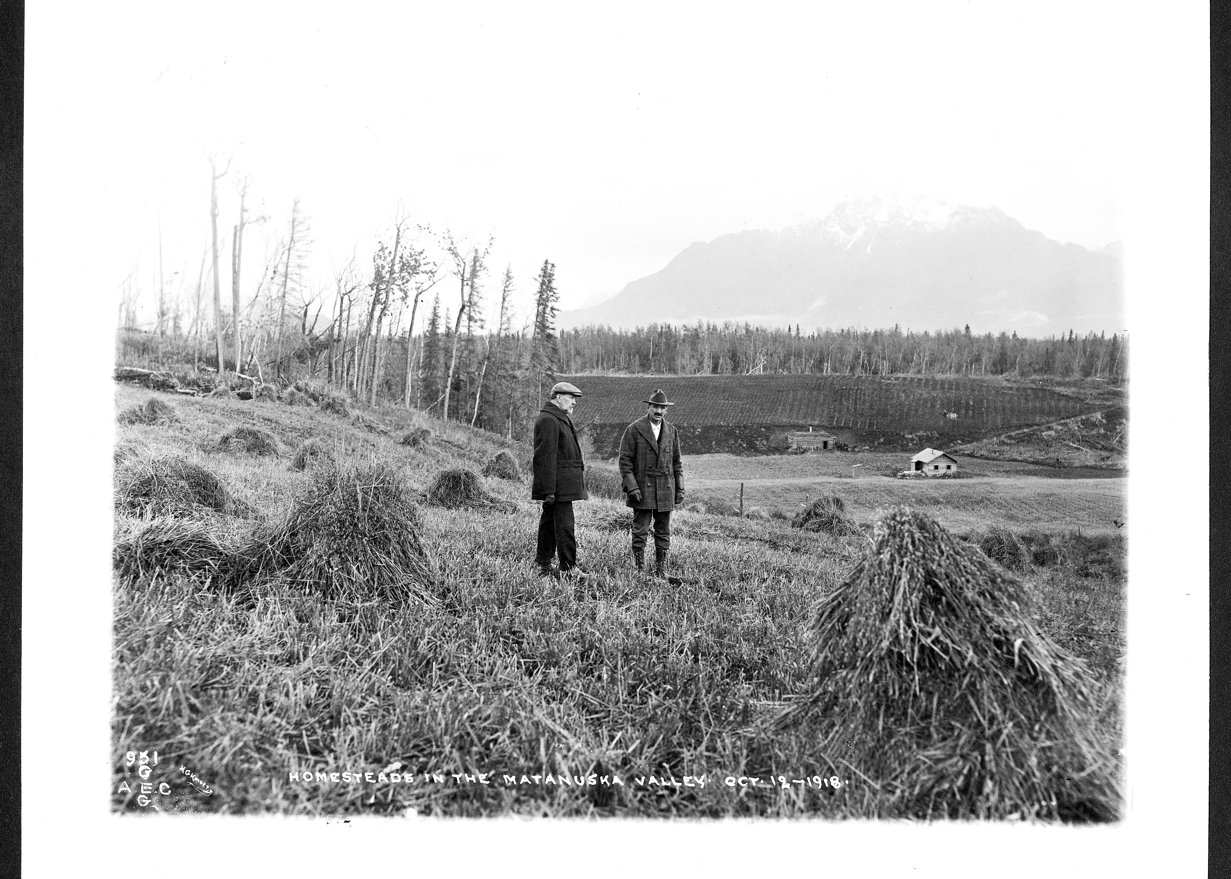
AEC G951 HGK Verso: H.G. Kaiser photo. Matanuska Valley, 1900-1930 [Two men standing among haystacks on homestead, Matanuska Valley, with buildings in background]


Attribution-NonCommercial-NoDerivatives 4.0 International (CC BY-NC-ND 4.0)
AEC G951 HGK Verso: H.G. Kaiser photo. Matanuska Valley, 1900-1930 [Two men standing among haystacks on homestead, Matanuska Valley, with buildings in background].
The Hatch Act of 1887 established agricultural experiment stations across the United States and its territories to provide science-based research and support to farmers. In Alaska, these stations focused on introducing vegetable cultivars suited to the region's climate, as well as on animal and poultry management.
In 1914, the U.S. Department of Agriculture conducted a preliminary soils survey of the Southcentral region in the Matanuska Valley and approved the establishment of an experimental station in 1915. A 240-acre site was chosen just north of the Alaska Railroad, about six miles north of the Knik River and seven miles east of the new town of Wasilla. Work on the station began in April of 1917. The station’s first few years were focused on land clearing, constructing buildings, and launching research projects. Between 1917 and 1929, five structures were built that still stand today: the manager’s house, the Kodiak Cottage (originally located at the Kodiak experiment station and relocated to Matanuska in 1922), a mess hall, a dormitory, and another residence known as the Herdsman’s House.
The early research conducted at the Matanuska Experimental Station influenced the federal government's decision to designate the region as the site for one of the rural rehabilitation colonies established under Franklin D. Roosevelt's New Deal, aimed at alleviating the effects of the Great Depression. Created by the Federal Emergency Relief Administration, this initiative became known as the Matanuska Colony Project. Beginning in the 1930s, the project introduced approximately 1,000 new residents, including colonist families and transient workers. The influx of people spurred the need for expanded infrastructure, including additional roads and settlement areas. By 1966, the population of the Matanuska Valley had grown significantly, with an estimated 20,000 acres cleared and farmed. However, these land developments disrupted the food pathways and seasonal lifestyles of the Ahtna and Dena'ina Peoples which disrupted cultural practices (including traditional language fluency) and traditions, the impacts of which have not been fully restored to this day.
The Matanuska Valley is primarily associated with the Dena’ina Athabascan name Ch’atanhtnu, meaning “trail comes out river,” referring to the Matanuska River and its role as a key travel corridor. For Dena’ina Peoples, the area holds cultural significance as part of their traditional homeland, supporting seasonal movement, subsistence activities, and connections between inland and coastal regions.
Ahtna Peoples refer to this region as Ts’itonhtna' and have longstanding relationships to the valley through trade, travel, and interregional connections extending from their primary homelands to the east. The name “Matanuska” is believed to derive from a Russian term associated with Ahtna Peoples—historically referred to as “Copper River people” or Mednovtsy—who frequented the valley for trading.
The Matanuska Valley has historically functioned as a place of convergence—of waterways, people, and cultural exchange—reflecting the interconnected lifeways and enduring relationships both Ahtna and Dena’ina Peoples maintain with this landscape.

Attribution-NonCommercial-NoDerivatives 4.0 International (CC BY-NC-ND 4.0)